If you’re tracking Hurricane Matthew this weekend, you’re likely to stumble on some misinformation on the internet.
From Hurricane Joaquin to the Jonas Blizzard, extreme weather sets off a storm of events on the internet. A wave of information—some of it misleading or useless—hits Twitter as soon the storm’s name begins to trend. Eerie retweets of skull or vagina-shaped satellite images compete with evacuation warnings for attention on your feed. Armchair meteorologists and disaster hoax theorists abound.
“Anyone can play a meteorologist on social media nowadays, and I’ve seen it hundred of times,” said WGGB-TV meteorologist Jacob Wycoff told the Daily Dot.
Snowfall maps or hurricane forecast models can go viral in an instant, often shared without context or chances of their likelihood.
Wycoff said the spread of hurricane information shared on Twitter and Facebook has forced meteorologists to stay on the cutting edge of trying to be the most accurate. But a big downside is that people can be lead astray.
Coincidence much?#HurricaneMatthew pic.twitter.com/6oB9Lf3ydj
— Stephanie (@Plurprincess_1) October 7, 2016
Take the case of Hurricane Matthew, which as of Saturday morning weakened to a Category 1 storm and began its strike on South Carolina’s coast. Florida was spared the direct impact of what on Thursday was expected to be a Category 4 storm that the National Weather Service warned would be “unlike any hurricane in the modern era”. Luckily, Matthew slowed its simmer to a Category 3 storm by Friday morning and did not hit landfall.
The Drudge Report on Thursday cast doubt on the severity of Matthew and pushed a conspiracy theory that the National Hurricane Center was lying about its hurricane models in order to push the idea of climate change to the American public.
Many said Matt Drudge’s actions were dangerous, and could have led people remain in their homes or not prepare for Hurricane Matthew.
Wycoff said that Drudge’s words de-legitimized the actions of the National Hurricane Center, news networks, and meteorologists to get accurate weather forecasts out to the public. Drudge’s tweets planted a “seed of doubt” in at least some of his followers.
“There’s a portion of (Drudge’s) followers that are like, ‘Oh, he’s right—the government is lying to us about hurricanes!’” Wycoff said.
At the same time, meteorologists are under fire for adding to the weather hype. Fox News’ Shephard Smith pushed out a doomsday forecast of the storm that was mocked on Twitter.
“This moves 20 miles to the West, and you and everyone you know are dead. All of you. Because you can’t survive it. It’s not possible unless you’re very, very lucky. And your kids die too,” Smith said about the potential havoc a Category 4 storm would cause Florida.
https://twitter.com/Deathbymartymar/status/784122375424004096
The difference between a Category 3 and a Category 4 storm is significant. But to call Mathew “fizzling” as The Drudge Report described it would be a massive understatement. Central Florida is facing flooding, damage to house, and nearly a million residents are without power as of Friday afternoon. Matthew’s western eyewall is brushing Florida’s coast at a breakneck speed. Coastal cities in Georgia, South Carolina, and North Carolina are expecting major flooding.
“It’s really a different ball game now,” WOFL-Fox 35 meteorologist Jayme King told the Orlando Sentinel. “Hurricane Matthew was going to be unlike anything these communities had ever seen. It’s still a dangerous and powerful storm, but the outlook has improved significantly.”
A Category 4 storm would have meant most of the area in the storm’s path would be uninhabitable for weeks or months, according to the National Hurricane Center. Well-built houses would lose their roofs. Downed power lines and trees would block residential areas. Power outages could last for months. Category 3 storms can still expect “devastating damage”, including damaged homes and down trees and power lines.
How do you parse hurricane reality from hurricane hype? The Daily Dot spoke to meteorologists to get their advice how to deal with the deluge of hurricane information flying in from the internet.
Leave interpreting the models to the meteorologists, not Twitter
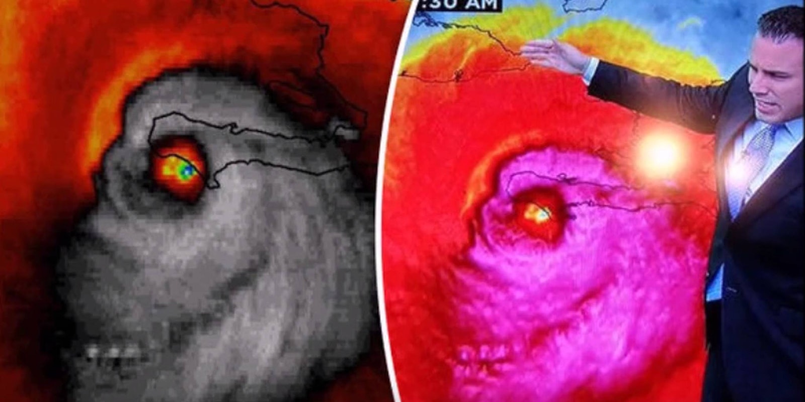
Hurricane Matthew is a real monster, looking like a skull from satellite radar as it hit Haiti. pic.twitter.com/PNopqY2CCX
— tim cornwell (@247razz) October 5, 2016
You’ll often see forecasting models differ in their predictions. Which hurricane forecasting model is the most accurate?
“Unfortunately, the most accurate model changes from storm to storm. If there was one that was the most accurate, meteorologists would be using that model all the time,” Ferrell said.
Ferrell says meteorologists will often pick what they feel is the best model for the job. There are multiple weather models that have their own strengths and weaknesses. The European ECMWF model is widely considered the best in predicting storms overall. The National Weather Service runs the GFS model, which is widely considered to be inferior to the European model. The GFDL and the HWRF models are also in use for hurricanes.
Meteorologists advise against jumping to a conclusion based on a single image of a hurricane radar screen or a model with a five-day or even three-day forecast. Those forecast models you see retweeted a million times are still just predictions, not impact. Meteorologists add context when they read models that can give a more accurate picture of what danger could be ahead. Even hurricane tracking apps with the same raw data can be less reliable than television weather forecasts if they don’t have a meteorologist interpret the results.
“We’re not to the point that computers can accurately predict the weather. We need meteorologists to take into account the current weather picture all over the globe and historical trends,” said Jesse Ferrell, the social media coordinator for Accuweather.
Meteorologists will often look at a series of models to get a more accurate picture of events.
Models and forecasts get outdated quickly, so refresh that feed.
https://twitter.com/mattlanza/status/784053384311558144
Neither the U.S. or European models are especially good at predicting forecasts way in advance. Models with five- or three-day forecasts are still just guesses, and ones that are a week old are essentially useless. A storm’s exact path can be difficult to predict even a day in advance.
“Forecasts even up to the last minute will give a range and window of movement,” Ferrell said.
Hurricane Matthew was expected to be a Category 2 level hurricane last week, for example.
Be wary of hoax disaster shots and viral clips shared on Facebook and Twitter
Well, someone had to post this to Weather Twitter. #Matthew #LoopTheLoop @EricBlake12 @EricHolthaus @wxdam @ZLabe @mattlanza pic.twitter.com/GWXGz5oXYd
— Dr. Daniel Swain (@Weather_West) October 5, 2016
Is Hurricane Matthew going to make a return to Florida on its loop back? Still no guarantee. Turns out that’s one of the many several possible paths that Hurricane Matthew can take. Tampa meteorologist Paul Dellegatto tweeted the “loop” satellite map this week and it quickly went viral.
Meteorologists quickly laid it out. There’s no certainty of a loop at this stage.
https://twitter.com/mattlanza/status/783539490258292740
https://twitter.com/mattlanza/status/783542092698095616
Every new hurricane brings back the possibility of hoax photos being shared on social media. We all remember that shark swimming in the aftermath of Hurricane Joaquin. Be wary of photos and videos shared by those who aren’t local reporters who are on the ground.
Follow local stormchasers
WATCH: @RonMott reports from near the eye of Hurricane Matthew in Daytona Beach, Florida, on https://t.co/e63UsAxK7n. pic.twitter.com/ICGS3onm0E
— NBC Nightly News with Lester Holt (@NBCNightlyNews) October 7, 2016
Sure, there are are a litany of exciting new hurricane trackers, apps, and weather-related content out there in 2016. But the best technique remains the original one; follow your local weather news team.
It’s true that the Weather Channel and the major news networks have more money for sophisticated weather models and fancy graphics. But Wycoff notes that your local meteorologist has a historical knowledge of your region that bigger channels can’t compete with.
Local meteorologists can also give you valuable intelligence on evacuations or emergency services in your area.
